
Map

Alignment Map
LATAR Expressway links the townships of Kuala Selangor, Assam Jawa, Ijok, Batang Berjuntai, Kota Puteri, Puncak Alam, Shah Alam, Bukit Jelutong, Sungai Buloh, Kundang, Rawang and Selayang.
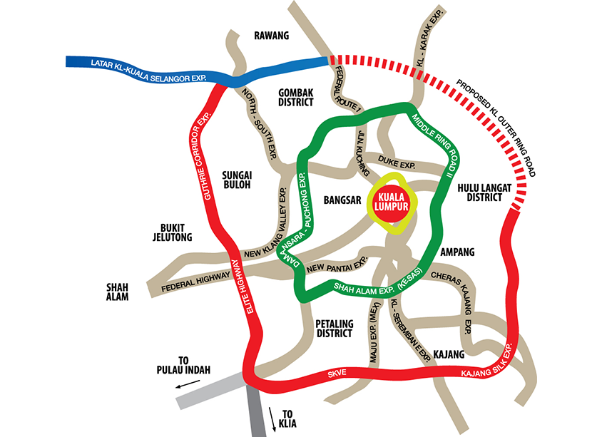
KLORR Map
The LATAR Expressway forms the North West portion of the Malaysian Government's bigger plan for a KL Outer Ring Road (KLORR) which begins from the Templer's Park Interchange along Federal Route 1 (KL-Rawang) to the Guthrie Corridor Expressway.
KLORR is a planned orbital ring road within the greater Kuala Lumpur area as an alternative to the present congested Middle Ring Road 2 (MRR2).
Currently, the completed sections of KLORR include the Guthrie Corridor Expressway linking to Elite Expressway from Bukit Jelutong, Shah Alam to Saujana Putra, and the South Klang Valley Expressway from Saujana Putra to Kajang. In addition KLORR connects Kajang to Hulu Langat via the SILK Highway.
With the impending completion of LATAR Expressway, 75% of the KLORR network would be formed leading to the Government�s greater vision for traffic dispersal that reduces congestion in Kuala Lumpur city.